Solo Climbing Washington’s Most Remote Volcano
Section Overview
- Miles: 33.4
- Elevation: 10,912 feet
- Car to Car Time: 12:58:45
- Dates: July 6, 2025
It’s hard to describe why exactly Dakobed has captured my attention so wholly. While my friends’ dreamed about climbing Tahoma (Mt. Rainier) and Kulshan (Mt. Baker), my thoughts always drifted to the volcano that is rarely seen from Seattle aside from the occasional glimpse of the summit between other peaks. Perhaps I romanticize the mystery of the peak due to its hiding away in an ocean of other mountains or even the thought of a required 30+ mile round trip piques my interest.
In 2024, Colin expressed his interest in climbing Tahoma and wanted to do some other volcanoes beforehand to get some additional experience. Dakobed was an obvious step up from other peaks we had done before and we nervously set off in August of 2024 to attempt to summit. The trip, like most I’ve done with Colin, turned out to be incredibly successful. The forecasted weather window held perfectly and we reached the top by via the Disappointment Peak route. On the way out, I remember telling Colin I wanted to attempt the entire route in a day.
The Day Before
I had originally bookmarked the weekend before for attempting a single day summit, but due the Mailbox to Granite linkup and frisbee starting, my legs were feeling wiped out. I postponed the attempt to instead do the Alpine Lakes High Route, which certainly turned out to be more difficult than I expected, but compared to the Linkup, felt like a good route to tackle the week before Dakobed.
I left Seattle Saturday afternoon, headed to the North Fork Sauk Trailhead. Along the way I picked up some dinner for the night and sent Colin a message about what I was doing and when to expect me back – promising him first dibs on any of my gear if I didn’t return.
Headed to Glacier tonight to attempt it tomorrow. If I wither away, you can have first dibs on my gear. Brent probably has enough
I felt some light nerves creep in as I left Seattle behind. I did my best to reassure myself that I could pull it off – the winter of running workouts had paid off with success on Tahoma, the i90 Linkup, and the Alpine Lakes High Route – as I made a quick stop for gas and suncreen, which I had forgotten. The only one I could quickly find was a Sun Bum Kids spray bottle – something I would regret many, many hours later when I discovered why it was branded for kids.


The North Fork Sauk Trailhead was unsurprisingly crowded for the holiday weekend when I arrived. I found a crooked spot for my car next one of the small camp spots and started setting up my tent. A woman walked by and we chatted about some beta along the route – I expressed my concern for the snow clinging to the notch just east of Marmot Knob and whether I should bring an axe or not for that specific stretch.
After eating dinner I packed my running vest deciding last minute to leave the ice axe behind and settled into my tent for the night. I originally told Colin I would be starting at 2:30AM, but decided to push it back to get a bit more sleep.
Summit Day
My alarm went off next to my head at 3:00AM. I had managed somewhere in the 4-5 hours of sleep, which, given the early wakeup, I was fairly happy about. I sluggishly packed up my tent while trying to choke down spoonfuls of cold soaked oatmeal. The morning efficiency I had developed thru hiking seemed to faded in the two years since I was on trail as I didn’t start my attempt until 3:37AM.
The first stretch of the North Fork Sauk Trail are a breeze, only gaining about 1,300 feet of elevation over 5.5 miles to Mackinaw Shelter Camp. The dark old growth forest prompted me to almost immediately reach into my pack to pull out my stronger headlamp than the small flash light I typically use. Much to my dismay, I had neglected to put batteries in the headlamp – such a classic mistake. Armed only with the small flash light that is amazing for hiking, but a bit lacking for running, I shuffled along the trail as quickly as I could, hiking the uphills and running the flats and short downhill sections.
Aside from rolling my ankle twice in some of the rockier sections of trail and coming across a giant Western Toad, the first section of trail passed by uneventfully. I had gotten used to night hiking years before going on post-work sunset hikes, but moving faster over terrain by only flashlight was new to me and my ankle suffered the consequences. Thankfully, though, the mishaps were inconsequential and both times I continued without stopping.


I sped passed what remains of the old shelter – now no more than a pile of logs – and began the climb up the notorious switchbacks. As I moved up out of the valley, the trees grew smaller, allowing the ambient light from the sun, which was still hidden below the horizon. The higher I climbed the lighter it got and soon I packed away my headlamp as I enjoyed the sun gracing the northeast face of Sloan Peak.

This was my third time climbing these switchbacks and each time they had felt easier – perhaps it had something to due with not carrying mini champagne bottles up to White Pass for a friends’ birthday camping trip. Above the tree line I sped along the mostly flat trail toward the PCT and White Pass, enjoying the the sunlight making its way down the face of mountains toward the valley, when I noticed some movement down the slope from me. I paused and was able to make out a bear digging for food in a patch of dirt.
After a brief pause, I continued on, making my way over the tongues of snow that lingered in a few spots, while looking out for the marmots and ptarmigan that seemed to be ever-present in the area. When White Pass came into view, I couldn’t resists stopping and pulling my phone out once again to take photos. The trails snaking from beneath my feet out to the grassy pass with Indian Head Peak as a backdrop was impossible not to revel at.


I reached White Pass 2.5 hours after leaving the trailhead, which wasn’t setting any records, but I intentionally moving slower than I probably could be to preserve some energy.
With a quick wave to some sleepy campers who were just emerging into the sunlight, I left White Pass and the PCT headed towards Marmot Knob and the notch that acted as a gateway to the White Chuck Basin.

The mild morning got a bit chillier when I reached White Pass with some gusts of wind chilling me when it hit the sweat on my shirt. I knew the easy terrain would disappear soon and I would be wishing for a cold breeze to cool me off.
The trail between White Pass and Marmot Knob was mostly straight forward with some slick snow crossings and a couple snow bridges over trickles of water. Throwing my microspikes on would have sped up the crossings, but would have slowed me down considerably – plus the consequences of losing my footing wasn’t worse than an embarrassing fall onto the snow or a wet shoe.
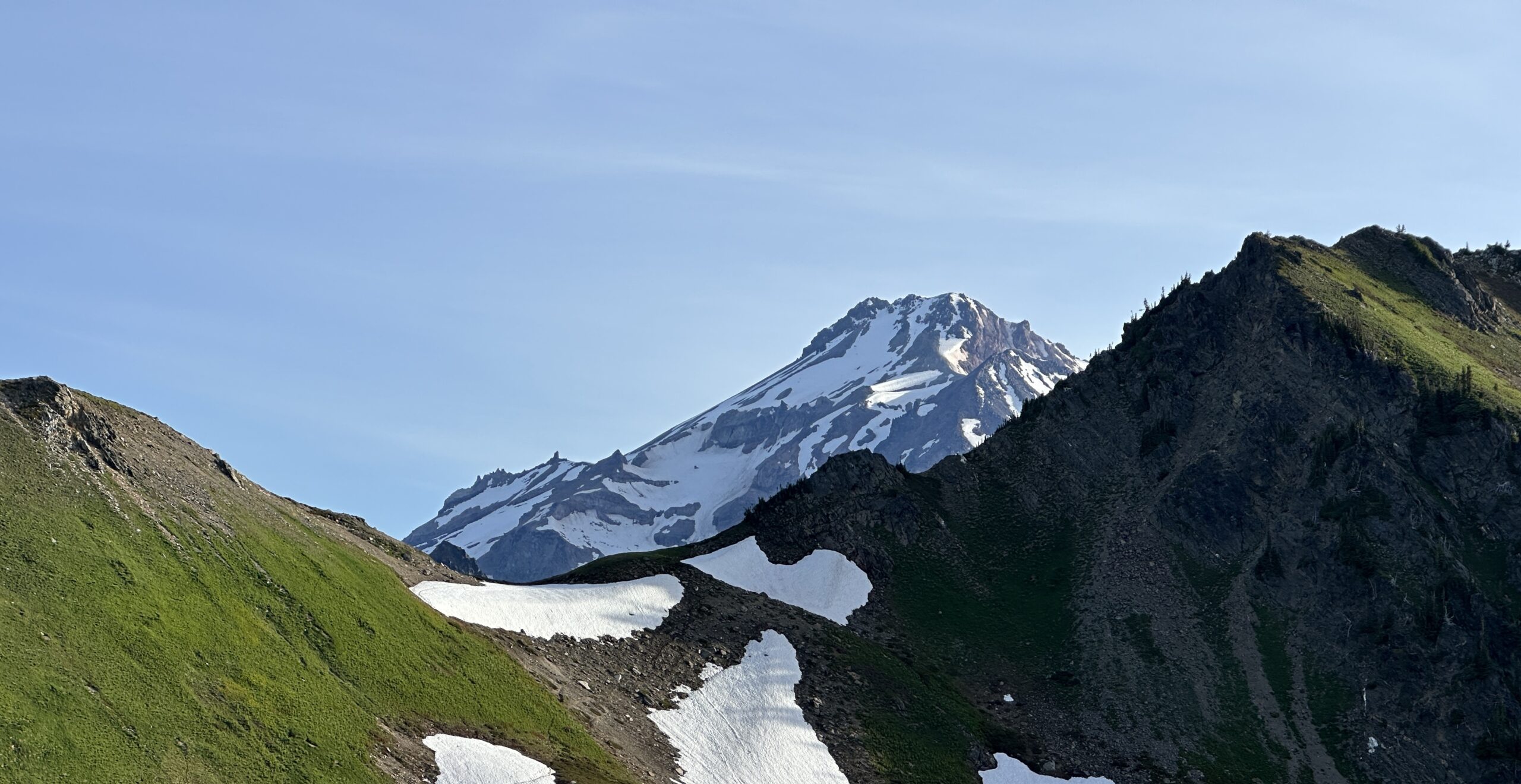
I crested the shoulder of Marmot Knob and was met with my first view Dakobed and a view of the one part of the route I was uncertain I would be able to pass. The notch that sat in between Marmot Knob and the White Chuck Basin had looked daunting to me on recent satellite knowing I would only have trail running and microspikes. But seeing in person it was clear there was a route up that didn’t require touch the snow.
I dropped off the shoulder of Marmot Knob and headed toward the notch. This is where the route gets exciting – the trail becomes less traveled and the terrain feels wild, remote, and unforgiving. I crossed the basin and soon I was cresting the top of the notch.


I only managed a few steps down into the basin before I had to stop to put on my microspikes. It was a little before 7AM at this point and I was hitting consistent snow that wouldn’t see the sun for many hours.
The last time I had been here, the snow was completely melted and Colin and I had to make our way through the moraine in the most efficient way we could. This time, I had a nice boot pack in the snow I could move more easily along. I passed some campers who looked to be getting their day started and hopped off the booth path to allow some climbers who were headed out after a successful summit. I congratulated them on their success and they wished me luck telling me there were a couple other folks ahead of me attempting the peak in a day.
I moved quickly across the snow in the White Chuck Basin, passing more and more tents as I neared Glacier Gap. At some point I remember passing a solo hiker, but we didn’t exchange more than a quick hello. I would later learn he was going car to car and started at around 6:30PM the night before.
I finally reached Glacier Gap, where Colin and I had camped the year prior just over 4 hours into my day. The summit, which was once again hidden was 2.5 miles and 3500 feet of elevation away and I was still feeling quite good. I ran into another runner – Jake – who was coming down to Glacier Gap. We talked for a bit, he had started at around midnight and encouraged me to consider taking the glacier route up and down as opposed to the scramble.


I climbed up and over a rise and descended down to meet the Gerdine Ridge. There were a couple climbers breaking camp at a small site, taking in the warm, unobstructed rays from the sun. I crossed over a small stream and decided to take a full break before tackling the steep flank of Disappointment Peak. I only had one liter of water capacity, so most of my time was spent cameling up on water. It still wasn’t particularly hot out, but the sun was growing more intense every step higher I climbed and the reflection off the snow only amplified that.
I ate some food and returned my flasks to their shoulder pouches. Before taking off, I pulled out the bottle of sunscreen and opened it up for the first time. I sprayed down my legs and arms and was hit by a bubblegum scented cloud. I gagged and nearly evacuated the food and water I had just consumed. I took a moment and a deep breath before covering my face and neck with the foul-smelling sunscreen, packed it away, and, 4 hours and 18 minutes into my day, started the real climb.


The first stretch of the Gerdine Ridge was straight forward. A loose bootpath snakes its way along the soft slope, occasionally splitting into two, only to rejoin again 20 or 30 feet later. I saw a figure above me sitting on a rock that grew larger as I steadily moved upward, feeling my breaths become slightly more labored as my body began feeling slight effects of the elevation.
I reached the man – Patrick – sitting on a rock and he started up a conversation with me, asking if I had seen his partner. It turned out he was also going car to car and was with the loan hiker I had passed on the White Chuck Glacier, but had been left behind because they were moving at different speeds. I was a bit surprised and confused to hear he was left, but the he was in good spirits and feeling strong and very accepting of the fact that he was going to have long day. After expressing how happy he was to be out in the mountains, he told me he had returned to the mountain because he and his girlfriend’s first date had been climbing Dakobed together over a few days and he wanted to retrieve a rock from the summit for the ring.
I left Patrick on his rock trying to work through everything he had told me (which also included working at REI as a pack fitter netted him more phone numbers than any other job he had ever had) and began working my way to the base of the scramble up to Disappointment Peak.


As I started the scramble, I was starting to hit a wall. I had struggled to get much food in on the way up most likely due to the elevation compounded by the occasional whiff of bubblegum that would cause me to gag every time I was hit by it. A year ago when Colin and I had tackled the scramble, a fresh coating of snow had covered the loose gravel. At the time I thought it made the route more difficult, but experiencing the amount of kitty litter and loose boulders I was slogging through was sapping my energy faster than I expect.
My pace slowed to nearly one mile an hour as I crawled up the ridge. I stopped, feeling my body beginning to over heat in the exposure. I sat down behind a boulder with a bit of shade, stretched out my legs, and took a full pause to try and get some food down. I managed to get a couple fig bars down and begrudgingly covered my legs and face again with sunscreen. I sat there for a few minutes looking at my map seriously considering turning around. I ultimately decided to keep going to the top of the scramble and check in again on how I was feeling. It was 9:50AM and I was a bit over 6 hours into my day, but I was still three and a half hours from my 1:30PM hard turnaround time and a few hundred vertical feet below the end of the scramble.
I finally reached the top of the scramble and was met with the third/fourth class move that Colin and I had spent a bit of time at the year before deciding to turn around or not. Something had shifted in the year since I had been on the move because it was slightly more awkward than I remembered, but I still moved through it without trouble and popped out next to the single cairn that marks the end of the scramble.


Emerging at the top of the scramble felt amazing. I skirted around Disappointment Peak, and dropped down onto the summit ridge where the scramble route and the glacier route reconnect. I ran into a man and woman who were about to hop onto the glacier. They asked me about the scramble and told me they had only seen one group rope up on the glacier and the two spots that were starting to open up were marked by sticks.
I thanked them and started up the final half mile and ~900 feet of elevation that remained to the summit. My legs felt a bit lighter as I moved up the ridge toward the final patch of snow between me and the summit. I ran into two groups of climbers coming down and talked briefly before parting ways.
I reached the summit right around 11:10AM and found I had it all to myself. I had covered ~16.5 miles and ~9,800 feet in just over 7.5 hours. Considering I hadn’t done much real running for a month and my inability to take in much food, I was very happy. I took a few minutes to eat some food and apply more sunscreen before I grabbed the summit register. I tried looking for Colin and my name from the year before, but was unsuccessful. I spent a couple minutes reading some of the entries – some were as simple as a name and a date, others told stories of hardships and training to climb the the mountain had helped them, and still more expressed their gratitude their bodies could carry them to such a wonderful place.


After a few minutes of soaking in the full Cascade Range from the summit, I started my descent. I moved slowly at first through the snow near the summit, taking big steps to try and land in the same spots others had. I slipped a couple times on the way down, but the risk of sliding was nonexistent, so I started to become more bold with my steps.
Eventually I got off the snow and down to the summit ridge heading to Disappointment Peak. At the edge of the glacier was the large guided group taking a break before the final climb to the summit. I was shocked that my snail’s pace up the scramble had beaten them on the glacier – on the way up I even asked one of the parties I saw coming down from the summit if the guided group was be at the top.
The group was quiet and didn’t really acknowledge me as I passed by. I couldn’t really blame them, though, they had been on the glacier exposed to the sun for well over 90 minutes only covering a mile at most and had probably gotten started around 2 or 3AM that morning.
At the summit I had weighed the decision to go back down the scramble route or take the glacier back. The lack of calories, elevation, and sun exposure were starting to weigh on me. I have repeatedly had issues with elevation and I was concerned the amount of time and care I would have to take on the descent of the scramble would dramatically extend my time on the mountain. I ultimately decided to follow suit with most of the other parties on the mountain and descend via the glacier unroped.


The beta I had been given by multiple parties on the glacier was spot on. I knew which area the crevasses were and the only one small opening on the route was marked as others had said it would be. I did a bit of probing in areas I was uncertain of, but the snow bridges that were still sitting over the gaps in the ice below were solid.
I started moving faster on the Gerdine Glacier after I got through the stretch where it meets the Cool Glacier. I was soon out of the crevasse zone and started run/sliding along the bootpath in the snow. I quickly caught up to the two groups I had seen coming off the summit – one on the glacier and the other where it rejoins the Gerdine Ridge.
I still had a long way to go, but I was off the technical stretch of the mountain and I felt a weight I hadn’t realized was there lift off of my shoulders. I hadn’t realized how focused I had been for the past couple hours since I got on the scramble and a wave of exhaustion hit me. I stopped below the climb just before Glacier Gap at the stream I had last filled up on water for a much needed break. I guzzled down the ice cold water and felt it hit my nearly empty stomach. Food had continued to be an issue, but I managed to get some Goldfish and Nerds Clusters down along with the water and climbed up and over the rise to Glacier Gap.


I dropped off Glacier Gap back towards the White Chuck Basin. I passed the woman I had seen getting on the glacier as I was headed up the summit block and learned she was in her 70s! As I passed more people, I took a look back up to Dakobed. I was shocked to see the guided group – now just the size of ants – descending off the summit. It was a gorgeous day out, but the sun beating down and it was only just starting to get reach the hottest part of the day.
As I crossed the White Chuck Basin, I could feel my body starting to over heat. Even though I was moving downhill, the sun felt like a hot blanket across my neck and it felt like my legs are face were being burned by the reflection off the snow in front of me. At some point I took a break, crawling as far under a boulder as I could into the shade, hoping to cool down a bit.
After a few minutes I got going again, but not before grabbing a handful of snow and sticking it in my hat. The snow almost immediately helped as I felt my body returning to a normal temperature. I continued shoving the now-soft snow into my hat as I returned to the notch near Marmot Knob. I reached the top feeling happy and strong, but exhausted.


I got a solid boot ski down from the notch to the trail below and I moved back across the basin to the shoulder of Marmot Knob. I started fully jogging at this point – or at least as much as my stomach would allow me. I attempted to eat a snickers bar, hoping to get something more than just Nerds in my system, but a few steps later, I was brought to a halt by my stomach twisting in knots. After a minute of trying to get myself to puke, I continued moving back to White Pass, trying to pick up my pace whenever I felt my stomach wouldn’t complain too much.


I told Colin I would shoot him a text when I was back at White Pass. As I pulled up the satellite messaging on my phone, I could feel that my brain was starting to zone out. I knew I only had about 9.5 miles back to my car and my brain wanted to go out auto pilot until I reached the end. I texted Colin and kept started along the PCT towards the North Fork Sauk Trail split.
Dear Colin, I am officially back at White Pass (ended up starting around 3:45). I definitely had something funny I was going to say, but I’ve forgotten. A pity laugh would be appreciated.
I cruised down the switchbacks to the valley floor and took a brief pause at Mackinaw Shelter before setting my sights on knocking out the final 5ish miles to my car. While it felt like it dragged on and I wasn’t moving incredibly fast, I was surprised I didn’t feel like I was suffering until the final mile.
I popped out at the trailhead just under 13 hours after I started happy to be back and happy I had managed to climb one of my favorite mountains for the second time.

Thoughts on the route:
- Colin never gave me that pity laugh
- This was my first time unroped on a glacier. I do believe I made the right decision taking the glacier down as it saved me a substantial amount of time and got me to lower elevation quite quickly. I think with more time roped on glaciers as I continue to climb in the Cascades, I will likely grow more comfortable and confident with making decisions like this.
- Nutrition continues to be an issue for me. When my body heats up, it seems like the first thing that goes is my appetite. Combining that with trying to get in enough electrolytes really made my stomach struggle in the final 12 miles. Over the whole day, I probably only consumed about 1,500 calories – based on the empty wrappers in my pack.
- Dakobed is still near the top of my list of peaks in Washington and I’m sure I’ll back. Maybe to try going car to car again?
Gallery


