Connecting 11 Peaks along the i90 Corridor
Trip Stats
- Miles: 20.48 Miles
- Elevation: 11,890 feet
- Days: 1
- Dates: June 14, 2025
- Peaks: Mailbox Peak, Dirtybox Peak, Dirty Harry’s Peak, Webb Mountain, Putrid Pete’s Peak, Mount Defiance, Little Bandera, Bandera Mountain, Pratt Mountain, Tusk O’Granite, Granite Mountain
The Plan
I’m not sure when this linkup/traverse first popped up on my radar (presumably while perusing Climber Kyle’s website), but I have been wanting to give it a try for a couple years. The only thing stopping me was a lack of confidence in my fitness level. My friend Brent and I attempted to traverse from Mailbox to Defiance a couple years ago, but rain and fresh snow turned us around quickly before we reached Dirtybox Peak. In 2024, I headed back with Colin and we completed a loop that included the Webb to Defiance traverse. With a bit more knowledge of the route and having spent the winter actually running and preparing for mountain adventures, I committed to giving the route an attempt in 2025.
The only obstacle in my path was figuring out how to get back to the Mailbox trailhead at the end of the day. The four obvious solutions were find someone who would/could do the route, hope to get a hitch, stash a bike, or ask a friend to be ready to head out to the pass in the evening to pick me up. After feeling excellent climbing Tahoma the weekend before, I had set my sights on a day to complete the route and while trying to decide what option I wanted to choose for a shuttle, my friend Zane reached out to myself and our friend Traut to ask about a trail run. In a bit of good fortune, he wanted to run up Granite Creek to Defiance and lollipop back by way of the Webb traverse. Traut was unable to make it, but Zane was willing to switch his plan up to start at Mailbox and do part of the traverse, which solved my car shuttle conundrum.
The Linkup
Zane and I met at the Granite Mountain/Pratt Lake trailhead around 7AM. I dropped my car and hopped in his, putting my car key in my “Don’t Die” bag hoping it would make it through the trip (even though it has never happened to me, I always assume my key will make its way out of my bag somehow). We drove back to the Mailbox Peak parking lot staring up at the ridge, which was currently completed shrouded in clouds. There was a small chance of rain in the forecast, but it was supposed to clear up around noon.
After a few last minute checks at the packed Mailbox lot, we set off, starting our big day at 7:40AM. Somehow it was Zane’s first Mailbox climb (I think it would be my 13th) and he got a good laugh at the sign marking the start of the Old Trail that says it will take 8 hours round trip. We started up the steep trail, which would knock out about 1/4 of the total elevation for me on the day in the first 2 miles. Thankfully it wasn’t particularly hot and we made quick work of the rough trail. We topped out at about 1 hour 15 minutes and joined the crowd of people sitting in a cloud taking photos of the mailbox. Zane took a quick second to check out the mailbox before we headed off into the abyss. There were definitely some hikers up there concerned for our safety as we disappeared into a cloud in the “wrong” direction.


The route from Mailbox to Dirtybox was straightforward, but tough to move quickly on. On the rare occasion we did get off route, it was apparent almost immediately. There were a couple borderline class 3 moves along the ridge, but nothing that caused concern, even in the damp conditions. The main crux of this section was just getting soaked by the moisture clinging to the trees and brush we had to push through. We reached Dirtybox a little under 30 minutes after leaving Mailbox (not out here setting any FKTs) and took a quick break before heading off towards the technical crux of the route.


In doing research on the route, the Dirtybox to Dirty Harry’s traverse seemed to be the main technical crux, with some folks running into a sketchy 4th class move. We moved very slowly through this stretch, working hard to stick to the gpx we had, hoping that would make travel easier. As my phone screen was basically useless due to moisture, Zane took over navigating and did an excellent job keeping us on route. There were definitely some annoying stretches getting to Dirty Harry’s Peak. The ridge was far from glamorous – perhaps being a cloud contributed to this – and wasn’t the engaging scramble. We never encountered any sketchy 4th class moves, but we did deal with some questionable side hilling on wet pine needles and sticks.
At some point we strayed a bit too far below the ridgeline and were forced to climb back up, which turned out to be a bit trick, utilizing rocks and trees to pull ourselves up. Eventually we reached the most fun part of the route – the fixed line. With cold hards and slick surfaces, it was probably more sketchy than it normally is, but still wasn’t too bad. The most annoying part was dealing with the one extremely dynamic line that required wrapping around our hand three or four times to get a good hold on.
We popped out on the top of the fixed line and a second later were on nice trail passing a view point that marked the Dirty Harry’s summit about an hour after we left Dirtybox.

At this point we were able to start moving a bit faster, which I was very thankful for. We were both soaked through from pushing through pine branches and overgrowth since leaving Mailbox. We moved quickly down the Dirty Harry’s Peak trail to the split of the Webb Mountain climbers trail. We avoided a patch of briars by rock hoping through the boulder field before rejoining the faint trail. Most of the time the trail through this area was apparent, but a couple times we had to refer to our gpx, especially when the pine needles gave way to rock hoping.
We tracked down some water flowing down into a little tarn near the start of Granite Creek and filled up. Until this point, we both had only needed about 2 liters of water to reach the first source along the route – one benefit of our slow pace to Dirty Harry’s and the cold temperatures, I suppose.
We gained the south ridge of Webb and enjoyed a few hundred feet of scrambling up to the summit where we took a quick break to eat some food about 1hour and 45 minutes after leaving Dirty Harry’s. The worst of the weather forecast was supposedly behind us, but we were still shrouded in clouds with only 50 feet of visibility. Thankfully, the summit and ridge were warmer than down in the wet basin and we didn’t feel rushed to get moving to stay warm.


Normally the ridge from Webb to Defiance is incredible fun – easy ridge walking with awesome views of the mountains and i90 snaking through the valley below. Zane had to trust my description of the views as we moved towards Putrid Pete’s Peak. It took us less than 30 minutes to reach P3, where we paused briefly before heading off towards Defiance.


The trail along the P3 to Defiance is well defined and we sped along it until we hit the Mount Defiance Trail. We actually managed to get a little bit of running in on the trail before heading up to the summit of Defiance! It took us about 50 minutes to hit the summit from P3, which had quite a few people lounging around, including someone Zane knew. After chatting for a bit, they left to finish up their day with Zane and me not far behind.

Zane and I said our goodbyes when we got back to the Mount Defiance trail. He jokingly took a “proof of life” photo as I jogged east into the clouds. He headed west along the trail to connect to the Granite Creek Trail, which would eventually dump him out near the Mailbox Peak lot.
The trail down to Mason Lake went by quickly and I managed to catch up to a couple of the groups of trail runners on top of Defiance. I sped past Mason Lake, enjoying actual trail. After the short climb out of the Mason Lake Basin, I found the turn off that would take me up to Little Bandera. In retrospect, I should have dropped a bit farther down the trail and take the standard route up to Little Bandera.
I passed over the top of Little Bandera without pausing and continued to the true summit of Bandera. I haven’t been to the top of Bandera before and was surprised at how long it took to reach. Eventually I spotted a small stack of rocks marking the true summit as well as two hikers sleeping on the rocky summit. We chatted briefly and they told me they had hung out on the summit for an hour or so hoping the cloud we were in would lift.


After taking a rest, I set my sights north, where I was about to once again lose all the elevation I had just gained. Island and Rainbow lakes were somewhere in the fog below and I thought all that lay in between me and more water was a large boulder field. The large granite blocks shifted frequently underneath my feet, but as the boulders faded away to trees, I was soon wishing for them. The steep and slippery dirt made staying upright difficult and I was often clinging to stiff brush in an attempt not to fall.
Eventually, after following small drainages and slipping on snow, I popped out of the woods at Island Lake and ran into a family I had met at Mason Lake. They had take the much more sensible route (i.e. the trail) back to their camp. After chatting with them a bit and filling up water, I carried on to my next objective – the turnoff for Pratt Mountain.
I managed to briefly lose the trail a couple times in between Island Lake and Rainbow Lake due to snow, but soon reached the spot where I was supposed to turn off. The route up Pratt through a large boulder field – far more stable than Bandera – and I quickly summited. It was a fun, albeit small, peak that at a different time would probably give great views of the surrounding mountains due to its relative isolation.


With nine out of 11 peaks done, I was surprised at how good I felt and started to actually feel confident about finishing the route. I quickly dropped off of Pratt, more or less along the same route I took up. Looking back, I realized I could have rock hopped down the southeast ridge of Pratt and connected back to the trail at a saddle where the Mount Defiance Trail and Pratt Lake Trails meet.
When I reached the saddle, I checked my map, making sure I should be heading back off trail. This was my last/best option for bailing to my car without having to do any backtracking. I was still feeling good and headed up the ridge line that I would follow up to Tusk O’Granite. At first I was making good time, but soon the faint climber’s trail faded into a crappy boulder field intermittently broken up by clumps of trees I had to navigate through.
My pace dramatically slowed down through this stretch. It wasn’t particularly difficult – just lots of big boulder hopping moves, with straight forward navigation. I probably could have saved time by staying off the ridge and sticking to the boulders, but nothing was difficult enough to convince my tired brain to lose elevation.
A small amount of fatigue driven frustation had started to set in as it felt like the ridge never ended, but suddenly, I was up on Tusk O’Granite. I found the summit register – the only one I had found all day – and opened it up to sign it. Unfortunately, there was no pen or pencil (presumably someone had dropped it into the rocky summit) and all I was left with was the last entry that just said:
“Traversed from Granite. Finally made it. What a slog.”


With that great quote in mind, I set off to reach the summit of the final peak of the route. I dropped down to a saddle, which turned out to be much faster than I expected with lingering snow. I was able to boot ski and glissade down the quick descent before starting up the other side. Once again, I started along the true summit as much as I could, but I was obviously forced just off to the southwest.
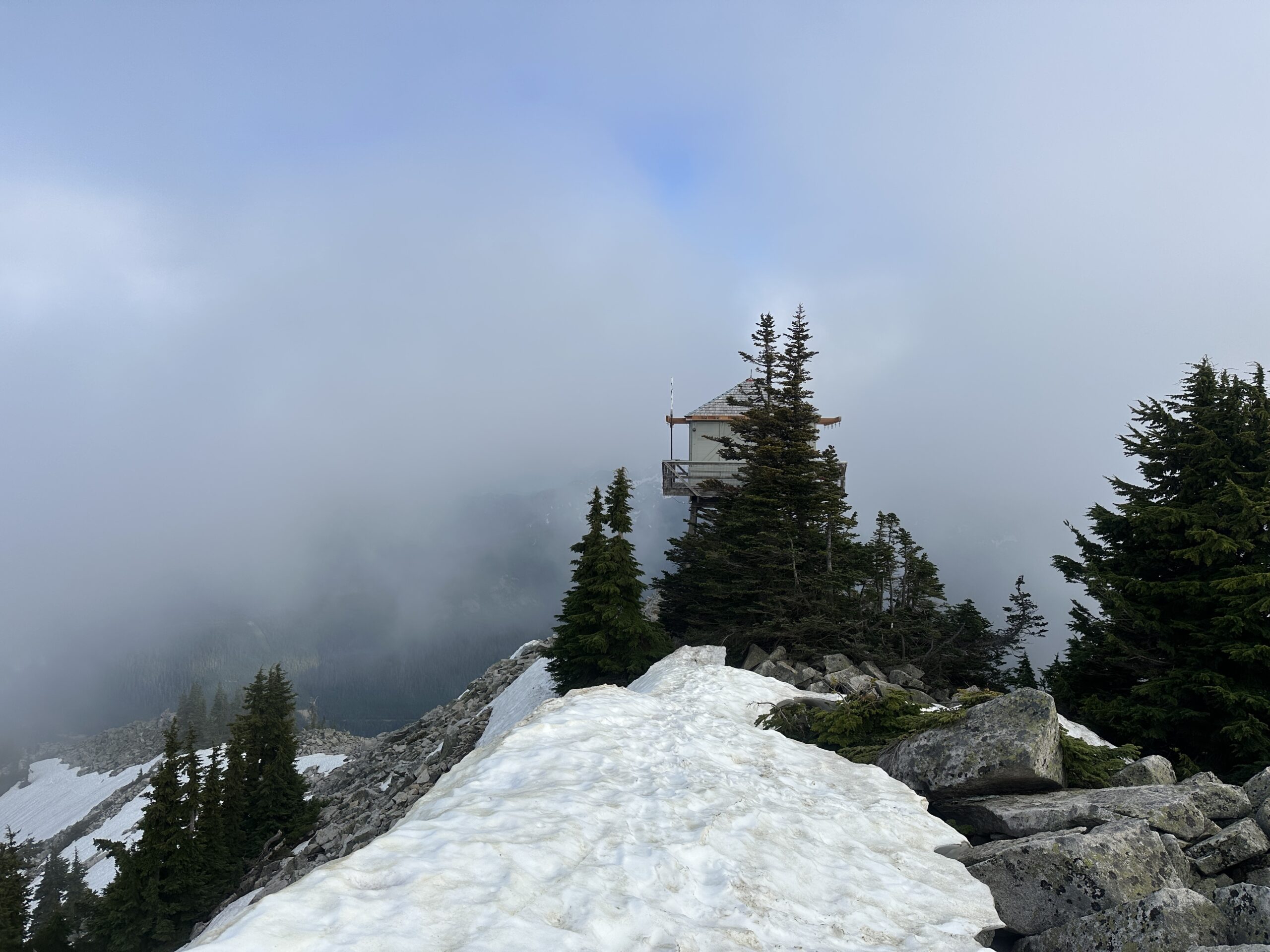
As I climbed the clouds were lifting more and more and I grew excited at the prospect of actually seeing some views from the lookout on top of Granite. To my surprise, the lookout popped into view way faster than I was expecting and a feeling of accomplishment started flowing over me. I checked my watch and I was already beyond the 11,000 feet of vert I expected the day to hold, which, as far as I was aware, was the most I had ever done.
I popped out onto the summit, stumbling a bit on snow and surprising a couple who had a tent set up to spent the night on the summit. I greeted them and headed over to the lookout. Unable to climb up into the structure, I took some photos of the surround mountain from underneath.


I didn’t linger long and began my descent. I opted to take the scramble route down, which seemed more direct than dropping to the north into the snow. I had a bit of fun hoping along the large boulders toward the inviting trail I could see down below. Finally, I reached the dirt trail and started speeding up, actually getting a few full jogging steps in. However, the trail turned out to be more rocky than I expected and my tired legs weren’t nimble enough to navigate the rocks quickly, so I slowed back down to a quick walk.
Somewhere along the descent, before reaching the tree line, I filled up with water and was greeted by a couple walking a cat on a leash. I laughed a bit at the cat trying to hide from me by just crouching in the middle of the trail and passed along, taking in the views as the sun began dropping lower.
The rest of the trail grew harder and harder. My quads were finally starting to really feel the pain of nearly 12,000 feet over elevation gain and they were not happy about losing about 4,000 feet over less than 4 miles. I shuffled down the trail, looking forward to the cold drinks I had stored in my car. When I finally reached the Pratt Lake Trail junction, I knew I was close to the parking lot and checked my watch. I realized if I hustled I could get in under 13 hours and I “took off” down the wide and well maintained trail.
I rolled into the parking lot 12 hours 59 minutes and 55 seconds after leaving the Mailbox Peak Trailhead.


Thoughts on the route:
- If you’re looking for a fun scramble route, this isn’t the route for you. If you’re looking for a tough challenge to push yourself on, then give it a shot.
- I was happy I was in the clouds most of the day. While there was plenty of water, I likely would have had to bring more if the sun had been out.
- Timing wise, I think I landed in the sweet spot. The snow I did encounter wasn’t bad to deal with and all expected water sources were flowing well.
- I had a lot of fun on this route, but I probably won’t be back for it again. With different conditions and knowledge of the route, I could undoubtedly go faster and it was fun to link everything together, but I think this falls into the category of “just plain hard.”


