Summitting Tahoma (Mount Rainier) – Washington’s Highest Mountain
Trip Stats
- Miles: 15.78
- Days: 2
- Dates: June 6 – 7, 2025
- Route: Disappointment Cleaver Route
The First Big Climb
Early in 2025, Brent, Colin, and I sat down to plan out a number of trips as we had the previous year. 2024 had brought a number of successful trips for all three of us – at least when Colin was around (looking at you, Alpine Lakes Crest Traverse) – and we hoped to continue the trend into the new year. The main objective for this summer was clear – Tahoma. Last year our major summits included Loowit (Mount Saint Helens), Wy’east (note that there is some skepticism around this being the true indigenous name for Mount Hood), and Dakobed (Glacier Peak) and we were ready to take the step forward to attempting one of the most difficult mountains in Washington.
While all three of us have extensive experience in the mountains, the challenges surrounding even the easiest route on the mountain were a step above what any of us had successfully completed before. Beyond the requirement for roped travel and crevasse rescue skills, the summit of Tahoma sits around 14,400 feet above sea level, which adds substantial risk of getting altitude sickness.
However, with a strong desire to see the summit of the mountain the three of us stare at near-daily, we prepared our bodies as best we could to reach the top quickly and efficiently to minimize our time at high altitude.
Day 1: Seattle to Camp Muir
I woke up on Friday with a mixture of excitement and nerves. I was confident in my abilities, but the memory of my brutal expedience with altitude sickness in 2020 on a 5 day trek across the Uinta Mountain Range, was weighing heavily on my mind as I drove to pick Colin up.
After Colin and I reached Brent’s apartment, we transferred all our gear out of my car and started our trip down to Paradise. Not long after leaving Brent’s, before we were even out of Seattle, our trip almost ended early when a driver nearly merged into our car on the highway. We made a few jokes about it being a bad omen, but continued to our destination.

We arrived at the crowded Paradise lot around 10:30AM and, after picking up the required permits, we did some final gear checks and left our car behind to start the climb. We planned to attempt the mountain in early June, assuming the route would be stable and crevasse danger would be low, but the last few days of blazing heat had made conditions relatively uncertain. Nevertheless, we set off, all of us opting to wear shorts, at 11:26AM from the trailhead, weaving our way through the throngs of tourists and large guided climbing groups.


The snow beneath our feet immediately began to soften, making each step we took include a small slip in a random direction. The climb to Camp Muir is a bit of slog. The route simply follows the large snowfield that extends down from Camp Muir, which is devoid of trees or shade of any kind. However, as tough of a slog the climb is, the expansive views behind us sucked me in whenever I needed to pause for a brief rest. The blast zone of Loowit was clearly visible, along with the massive dome of Pahto (Mount Adams) and the jagged summit of Wy’east over the border in Oregon.


As stunning as the views were, I was soon done with the inescapable sun and just wanted to be settled at camp. Our conversations dwindled as we passed by a few larger guided groups who clearly were feeling the weight of their massive packs. I was growing increasingly impatience with the tiny steps the many boot packs we were following and started carving my own steps up the steep snow. After a bit of head-down grinding, I realized I had put a bit of distance between myself and Colin and Brent, so I found a good spot to stop on some exposed rocks where a skier was taking a break and settled down to wait until they caught up.


With just under 1,000 feet of elevation left to Camp Muir, our impromptu break spot turned out to be a solid choice. We spent enough time on the rocks that the sweat soaking out shirts became cold enough to force us to continue our march upwards. Camp Muir quickly came into view after we started back up. It looked impossibly close to still be 1k feet below it, but we were still moving well and reached the famous camp quickly.


We arrived at Camp Muir around 3:45 and were soon working on our camp chores. The rest of the afternoon and evening was spent setting up camp, boiling water, and chatting with the rangers stationed there – giving them our plan for our summit bid and receiving info they had on the route. After learning when the other teams were going to head out, we decided on leaving for the summit at 12AM the next morning, hoping we wouldn’t have to deal with getting around too many of the guided teams.
With a start time set, we tucked in for the “night,” around 7PM, hoping to at least get 4 hours of sleep. Before attempting to get to sleep, I did quick lay out of all my gear, ensuring I could get up and go the next morning. I’m not sure how much I slept – my watch gave me a grand total of 27 minutes – but I do know around 8:30PM, a group rolled in to Camp Muir, loudly chatting and proceeded to set up camp right next to my shelter. I was able to ignore the scraping shovel as they dug out spots for their tents, but it was tough to ignore the couple of time snow inadvertently hit the walls of my shelter and the seemingly near-breakup of one of the couples that happened 4 feet from my head.


Frustrated at the lack of consideration and conversations being had not related to actually climbing the mountain we were on, I drifted in and out of sleep until 11:30PM rolled around and it was time to start moving.
Day 2: Summit Day
Our attempt to get our of camp efficiently didn’t go super well and we found ourselves roping up didn’t quite go according to plan and we started our summit attempt at 12:22AM. We roped up in the dark and took our first steps out onto the Cowlitz Glacier.


Perhaps it was just a slow start or perhaps it was just the sheer size of every milestone making them feel close, but I was surprised at how long it took to get up and over the ridge and put Camp Muir out of sight. Not long after our basecamp disappeared, we ran into the two rangers who were stationed at Camp Muir descending from their overnight summit. They gave us a bit of beta on the route, giving an additional warning about the snow bridge over the “High Crack” before we parted ways.
Soon after we hit the first of the guided teams on the Ingraham Glacier. Luckily we were able to pass some of them as they paused before heading up the Disappointment Cleaver, but we were quickly stuck behind a group that gave no indication they would pause to let us pass. We made our way slowly through the rock and snow – a little awkwardly while short roping and wearing crampons – until we crested the top of the cleaver and ran into a number of groups taking a break right around 2:40AM. We had originally planned to eat a quick breakfast on top of the DC, but seeing the number of people we had just caught up to, we opted to only pause for a few minutes before getting out in front of the main bottleneck of groups.
After leaving the DC, it felt as though the real climb just began. We quickly moved around two guided groups who had also just started back up when the guides told us we should pass. Pickets started appearing every so often, left by guiding companies to ensure comfort and safety of their clients.
Aside from the massive looming presence of Little Tahoma that we were slowly climbing higher and higher above, there wasn’t much to see in the dark of the night aside from our slow footsteps moving up the mountain. We crossed a number of snow bridges over crevasses, occasionally having to hop over gaps that descended into blackness beneath us. Without any ladders to deal with, we were making good time and we continued to catch up to teams that had started well before us. First light was just starting to show as we passed the final group that was ahead of us as they were taking a break and we had the rest of the climb to ourselves.
The impact of the altitude had started to rear its head. Aside from general fatigue, around 13,000 feet, I started to lose my appetite. Knowing I would be in a world of hurt later on if I didn’t eat anything, I continued to force myself to eat food every so often, which inevitably led to some slight nausea the higher we went.


Reaching the crater rim felt like it happened all of sudden, but cresting the ridge may have been the most satisfying moment of the entire trip. It was 4:46AM and somehow we had beaten the sun to the crater along with all of the other parties on the mountain. The true summit still sat 1/4 mile away across the massive crater left behind after an eruption, but the final stretch would be a breeze compared to what we had just done. We unroped and headed across the crater to the summit.


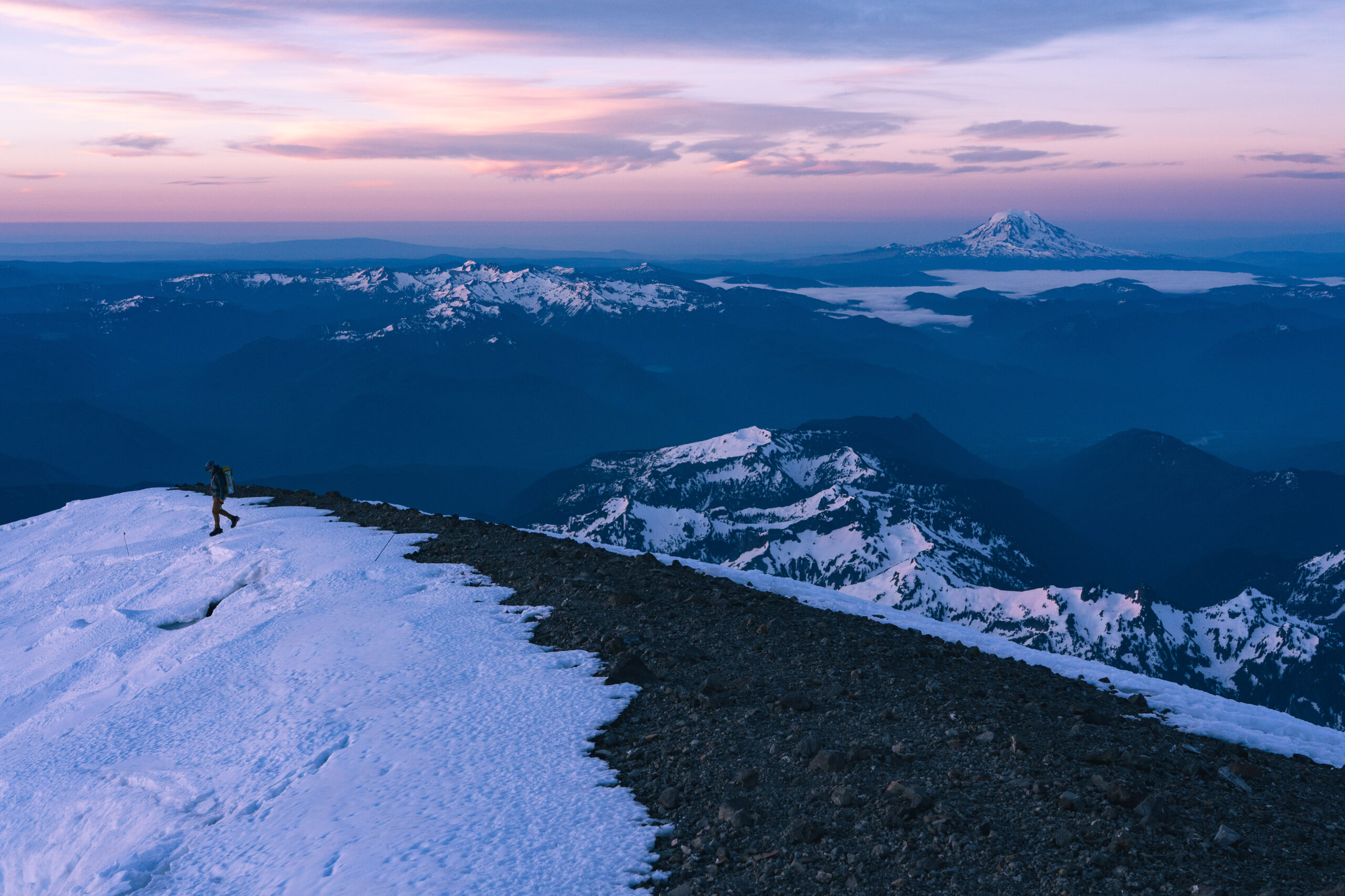
The summit ridge was devoid of snow and we slowly made our way to the high point. The Columbia Crest is no longer the true summit of Rainier, having melted down enough to be beaten out by the rocky rim. We had a brief celebration alone on the summit as other teams began cresting the crater rim down below us. The views as the mountains were gaining light were spectacular. To the north we could see Kulshan (Mount Baker) and Dakobed (Glacier Peak) and to the south, Pahto, Loowit, Wy’east, and Seekseekqua (Mount Jefferson). We took some photos at the summit before we were joined by the first of many parties behind us and started heading down.


After crossing back over the crater, we took a small break huddled behind a large rock so we could eat some much needed food. We left our chilly spot on the mountain at around 5:40AM and roped up again for the descent on the glaciers. The descent back to the top of the DC went quickly – we only had to step to the side a couple of times for guided groups inching along the well trodden path to the summit. Seeing Little Tahoma in the daylight was shocking. It looked like a mountain that belongs on a different planet jutting up out of the glacier’s flowing off of Rainier. The daylight also revealed how large some of the crevasses were that we crossed in the dark. While we still never had to take more than a large step, often to the left and right the crevasses opened into massive gashes in the ice. We reached the top of the DC around 7:10AM and sat down, looking back up at the ants moving back and forth across the face of the mountain.


While descending the Cleaver, we got passed by two climbers, who were moving quite well. Presumably they must have started after us and I remember feeling jealous of the extra sleep they got. The route down the DC was frustratingly slow to say the least. We unroped to make the descent more manageable, which was definitely the right move, but it was still slow going clambering down the chossy rock in mountaineering boots.
While descending, we got our first real view of the “High Crack” we had passed over in the night. It suddenly became very clear why the rangers warned about the snow bridge. The crevasse was massive and a fall into it could easily swallow two climbers with ease. We watched, with a bit of unease, as the two climbers who passed us stopped on the bridge to star into the void. Thankfully, they passed on without incident and soon is was our turn. We quickly moved across the snow bridge and sped our way across the rest of the Ingraham Glacier.


Brent was suffering a bit from the heat that was bearing down on us, even in the early morning and we kept moving quickly across the bare rock to the Cowlitz Glacier and into Camp Muir almost exactly 9 hours after we had left. Brent grabbed his things and sought shelter from the sun in the shadow of one of the toilets as he packed up. Colin and I haphazardly packed up the rest of the gear, downed some water, and grabbed Brent for the final stretch down the Muir Snowfield to Paradise.
Before leaving Camp Muir, Colin triumphantly pulled out his surprise he had been alluding to the whole trip – a “Skooty Booty” – a thin piece of material you strap to your waist and legs that helps you glissade down the mountain faster. As I was laughing at how ridiculous it was, multiple people came up to Colin asking how he got his hands on a Skooty Booty.
Brent, a bit rejuvenated from his time in the shadows, Colin, grinning in vindication, and myself, laughing at the giant blue diaper wrapped around Colin’s waist, departed Camp Muir and began the slippery descent down to Paradise. We made quick work of the descent, glissading anything we could and arrived back at Paradise at 11:58AM, just over 24 hours from when we left yesterday. We briefly celebrated at the car, before heading down off the mountain in search of our first option for food, happy to have had a successful summit.


Notes
- While the DC route was crowded, it was probably the best foray for us into climbing on a true big-mountain route
- With that in mind, I’m not sure I will venture back to Camp Muir. It’s a stunning campsite, but the frustration around other people being unnecessarily loud has sat with me.
- All around, I was surprised at how simple our trip was. Without a doubt, our preparation (physical and skills) and timing (not having to deal with ladders and large crevasse crossings, certainly played a part in a smooth adventure.
- I’m already plotting to give this route a shot in one day. Maybe next year it’ll be on a board or maybe I’ll manage to get up there are “run” it later this year.
- Tahoma is without fail one of the coolest mountains I have ever been on. Even reaching the top of the Cleaver would have been an exceptional trip. The views are spectacular and it becomes a bit easier to comprehend just how massive Tahoma is when you’re up on it.
Gallery


